Different Models#
Here we will show you the different models that are available in eWaterCycle and what their benefits, outputs and needs are. The outputs will be in daily form, unless mentioned otherwise. NOTE the following notebooks are from their respective GitHub pages and are not meant for this getting started guide specifically.
HBV#
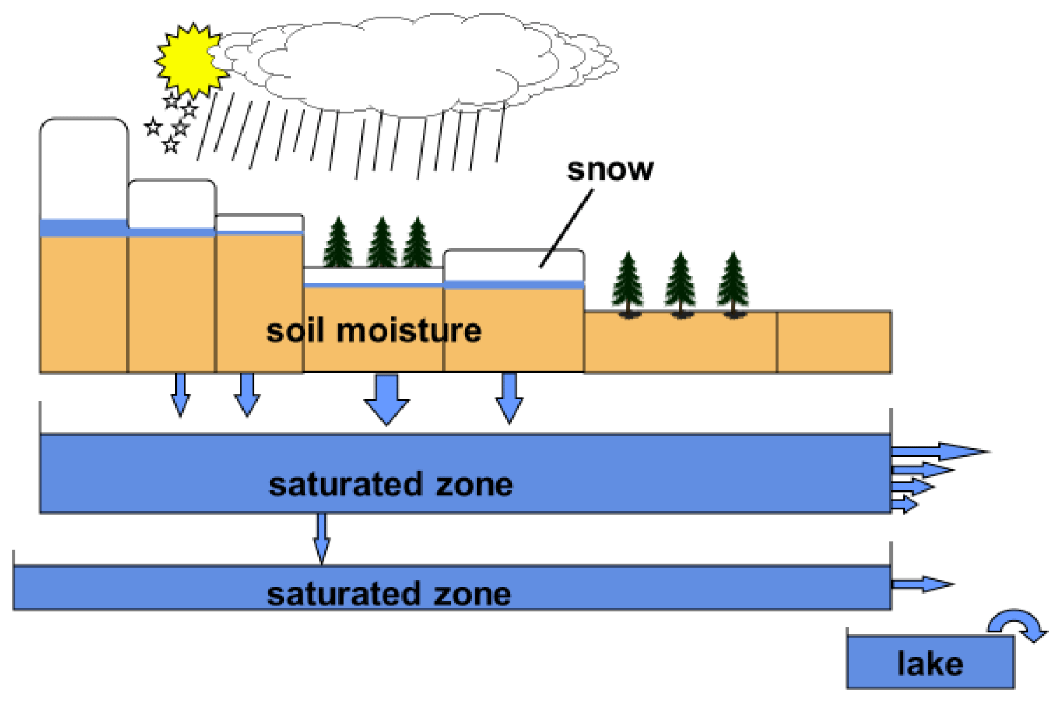
HBV (Hydrologiska Byråns Vattenbalansavdelning) is a conceptual hydrological model. For more information on its history, see this paper. The actual model implemented here sit looks most like the original model from 1976.
The model simplifies the entire water cycle into a few key processes and splits them up in five buckets:
Snow reservoir
Interception reservoir
Unsaturated reservoir
Fast reservoir
Slow reservoir
These buckets can be seen as reservoirs that store water and release it based on the catchment characteristics.
 A retrospective on hydrological catchment modelling based on half a century with the HBV model. https://hess.copernicus.org/articles/26/1371/2022/
The structure of the HBV model is shown below.
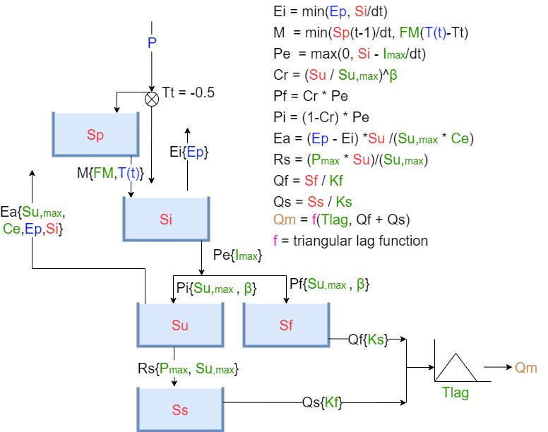 Image from the TU Delft course ENVM1502 - “River Basin Hydrology” by Markus Hrachowitz.
With the abbreviations:
|
|
|
||||||||||||||||||||||||||||||||||||||||||||||||||||||||||||||
Benefits#
A well-established, conceptual model ideal for simple catchment-scale studies.
Easy to set up and fast to run, making it great for:
Academic research,
Education and training,
First-look flood modeling.
Requires minimal data; good for data-scarce regions.
Calibrated models are robust for flood forecasting and climate impact assessments.
Suitable for hydrologists who prefer a lightweight, proven model with a long history of application.
Outputs#
discharge
Model Needs#
Forcing:
Precipitation
Incoming solar radiation
Temperature
Calibration parameters:
Imax: Interception capacity
Ce: Soil runoff coefficient
Sumax: Max soil moisture storage
Beta: Shape parameter for runoff generation
Pmax: Percolation threshold
Tlag: Routing lag time
Kf: Fast runoff recession coefficient
Ks: Slow runoff recession coefficient
Fm: Snowmelt factor
PCRGlobWB 1.0#
PCRGlobWB (PCRaster Global Water Balance) is a large-scale hydrological model with official documentation. eWaterCycle documentation.
PCR-GLOBWB is a large-scale hydrological model intended for global to regional studies and developed at the Department of Physical Geography, Utrecht University (Netherlands). PCR-GLOBWB provides a grid-based representation of terrestrial hydrology with a typical spatial resolution of less than 50×50 km (currently 0.5° globally) on a daily basis. Similar to other large-scale hydrological models, PCR-GLOBWB is essentially a leaky bucket type of model applied on a cell-by-cell basis. For each grid cell, PCR-GLOBWB uses process-based equations to compute moisture storage in two vertically stacked soil layers as well as the water exchange between the soil and the atmosphere and the underlying groundwater reservoir. Exchange to the atmosphere comprises precipitation, evapotranspiration and snow accumulation and melt, which are all modified by the presence of the canopy and snow cover. The exchange with the underlying groundwater reservoir comprises deep percolation and capillary rise and vertical fluxes are shown in next figure.
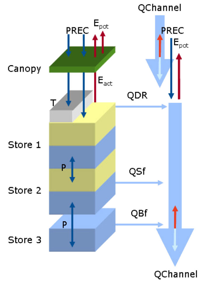 Model concept of PCR-GLOBWB. Left: layers describing the soil hydrology including the canopy, snow cover, soil layers 1 & 2 and the groundwater reservoir 3 as well as the exchange of moisture between them; right: specific runoff components and the direct gains/losses over the drainage network returning discharge along the channel when routed.
Taken from https://globalhydrology.nl/research/models/pcr-globwb-1-0/
Model concept of PCR-GLOBWB. Left: layers describing the soil hydrology including the canopy, snow cover, soil layers 1 & 2 and the groundwater reservoir 3 as well as the exchange of moisture between them; right: specific runoff components and the direct gains/losses over the drainage network returning discharge along the channel when routed.
Taken from https://globalhydrology.nl/research/models/pcr-globwb-1-0/
Sub-grid variability is taken into account as follows:
fraction of cell covered with short and tall vegetation;
fraction covered with freshwater, being either a river, lake or reservoir;
fraction glaciers;
sub-grid elevation distribution determining the accumulation and melt rate of snow and ice as well as fraction of the river plain flooded (optional);
soil type distribution and its effect on soil hydrological properties;
distribution of water-holding capacity of the soil resulting in variable saturation excess overland flow [Improved Arno Scheme, 2] as a result of variations in soil depth, effective porosity and elevation distribution.
Benefits#
A physically-based, global hydrological model designed for large-scale water balance studies.
Ideal for modeling water availability, groundwater dynamics, and human water use (e.g., irrigation, reservoirs).
Used in scientific publications and global water assessments (e.g., ISIMIP, World Resources Institute).
Strong for long-term scenario analysis under climate and socio-economic change.
Supports multi-decadal simulations and integrates with Earth system models.
Outputs#
PCRGlobWB has many different outputs:
Variables |
Variables |
Variables |
Variables |
|---|---|---|---|
accumulated_land_surface_baseflow |
accumulated_land_surface_runoff |
accumulated_total_surface_runoff |
bare_soil_evaporation |
baseflow |
bottom_elevation_of_lowermost_layer |
bottom_elevation_of_uppermost_layer |
channel_storage |
consumptive_water_use_for_irrigation_demand |
consumptive_water_use_for_non_irrigation_demand |
desalination_source_abstraction |
desalination_source_abstraction_volume |
direct_runoff |
discharge |
domesticWaterConsumptionVolume |
domesticWaterWithdrawalVolume |
evaporation_from_irrigation |
evaporation_from_irrigation_volume |
flood_innundation_depth |
flood_innundation_volume |
fossil_groundwater_abstraction |
fossil_groundwater_storage |
fraction_of_desalinated_water_allocation |
fraction_of_non_fossil_groundwater_allocation |
fraction_of_other_water_source_allocation |
fraction_of_surface_water |
fraction_of_surface_water_allocation |
groundwater_capillary_rise |
groundwater_depth_for_layer_1 |
groundwater_depth_for_layer_2 |
groundwater_depth_for_top_layer |
groundwater_head_for_layer_1 |
groundwater_head_for_layer_2 |
groundwater_head_for_top_layer |
groundwater_recharge |
groundwater_storage |
groundwater_thickness_estimate |
groundwater_volume_estimate |
industryWaterConsumptionVolume |
industryWaterWithdrawalVolume |
industry_water_withdrawal |
infiltration |
interception_evaporation |
interception_storage |
interflow |
irrigationWaterWithdrawalVolume |
irrigation_gross_demand |
irrigation_gross_demand_volume |
irrigation_withdrawal |
lake_and_reservoir_storage |
land_surface_actual_evaporation |
land_surface_evaporation |
land_surface_evaporation_fraction |
land_surface_potential_evaporation |
land_surface_runoff |
land_surface_water_balance |
livestockWaterConsumptionVolume |
livestockWaterWithdrawalVolume |
livestock_water_withdrawal |
local_water_body_flux |
lower_soil_saturation_degree |
lower_soil_storage |
lower_soil_transpiration |
netLqWaterToSoil_at_irrigation |
netLqWaterToSoil_at_irrigation_volume |
net_liquid_water_to_soil |
non_fossil_groundwater_abstraction |
non_irrigation_gross_demand |
non_irrigation_gross_demand_volume |
non_paddy_irrigation_withdrawal |
paddy_irrigation_withdrawal |
precipitation |
precipitation_at_irrigation |
precipitation_at_irrigation_volume |
reference_potential_evaporation |
relativeGroundwaterHead |
return_flow_from_groundwater_abstraction |
return_flow_from_irrigation_demand_withdrawal |
return_flow_from_non_irrigation_demand_withdrawal |
snow_free_water |
snow_free_water_evaporation |
snow_melt |
snow_water_equivalent |
surface_water_abstraction |
surface_water_abstraction_volume |
surface_water_level |
surface_water_storage |
temperature |
top_elevation_of_uppermost_layer |
top_water_layer |
top_water_layer_evaporation |
totalPotentialMaximumGrossDemand |
total_abstraction |
total_evaporation |
total_evaporation_fraction |
total_fraction_water_allocation |
total_gross_demand |
total_gross_demand_volume |
total_groundwater_abstraction |
total_groundwater_abstraction_volume |
total_groundwater_storage |
total_thickness_of_active_water_storage |
total_thickness_of_water_storage |
total_transpiration |
total_volume_of_water_storage |
total_runoff |
transpiration_from_irrigation |
transpiration_from_irrigation_volume |
upper_soil_saturation_degree |
upper_soil_storage |
upper_soil_transpiration |
water_body_actual_evaporation |
water_body_evaporation_fraction |
water_body_potential_evaporation |
Model Needs#
Forcing
Precipitation
Temperature
-
cloneMap
We have the needed data stored, you just need to give it your region.
A GitHub page on the inputs for PCRGlobWB 2.0.
Wflow#
Let us start with the documentation of Wflow, which is available here. Wflow is a fully distributed, open-source hydrological modeling framework developed by Deltares. It supports multiple process representations (e.g., HBV, SBM, routing) and is designed for both research and operational use, including flood forecasting and water resource management. In addition to the standard implementation, Wflow Julia is also available in via WflowJl, offering improved performance and integration with the growing Julia ecosystem for scientific computing.
Benefits#
Ideal for catchment to regional-scale modeling with high spatial detail.
More flexible and extensible than HBV or PCR-GlobWB.
Better for operational and real-time forecasting scenarios.
Uses modern formats (NetCDF, YAML) and integrates easily into scientific workflows (e.g., eWaterCycle).
Strong support for modularity, making it easier to adapt to specific hydrological or climatic contexts.
Outputs#
Discharge
Precipitation
Evapotranspiration
Runoff
Soil moisture
Storage – groundwater, snow, canopy, etc.
Infiltration and percolation
Snow water equivalent – if snow processes are modeled
Model Needs#
Forcing
Precipitation
Temperature
Evapotranspiration
Parameter set
requires HydroMT [work in progress]