1. Introduction#
1.1 Context to the research projection:#
In September 2015, low flows in the Lower Athabasca River (LAR) severely restricted navigation for the Mikisew Cree First Nation. At a discharge of 368 m3/s, navigation was described as “essentially at zero”, meaning that community members could not leave the harbour to fish, hunt, gather nor receive supplies by boat (Mikisew Cree First Nation, 2016). A year later, October 2016, another low flow event was associated with a Mikisew member having to pull a small boat across a sandbar in a distributary channel (Mikisew Cree First Nation, 2016). These events show that low flow conditions in the LAR directly affect river navigation for communities who depend on it.
Such low flow events may become more prevalent due to climate change. Rising temperatures alongside changing precipitation patterns can alter snow accumulation, snowmelt timing, evapotranspiration and seasonal discharge patterns. In cold region basins such as the LAR, these processes may influence the hydrology and the length of the open water season during which the river is navigable. The LAR forms a relevant case study for investigating how climate driven hydrological change may affect low flow conditions and navigability.
1.2 Problem Analysis#
The LAR feeds into the McKenzie River and is the largest undammed river in Canada, covering a basin of 160.000 km2 (Athabasca University, n.d.). The basin is home to several indigenous communities such as the Mikisew Cree First Nation and the Athabasca Chipewyan First Nation (Kashyap, 2022). These communities utilise a hybrid transportation system, relying on ice roads in winter and marine navigation and aviation outside of winter for the transportation of resources (Adam, et al., 2024; ADCS, 2026) with marine navigation being a cheaper alternative. Waterways are also used for hunting, fishing (Candler, et al., 2015) and evacuation routes during fires (Adam, et al., 2024) . Navigational routes for these communities are therefore of great importance (Canada Transport, 2020) and have been referred to as the ‘life blood’ for First Nations (Mikisew Cree First Nation, 2016). Low flow extremes in the Lower Athabasca River are expected to increase in frequency and severity over time (Mikisew Cree First Nation, 2016; Kashyap, 2022). If such critical water levels were to be reached more frequently, threatening navigational use of the river, it would be problematic for such indigenous communities who rely on it (Mikisew Cree First Nation, 2016).
1.3 Research Objective#
The goal of this Bachelor thesis is to quantify the impacts of climate change on the hydrology of the Lower Athabasca River and its secondary impacts. This leads to the following research question:
“How will climate change impact the river discharge of the Lower Athabasca River and what implications does this have for navigation?”
To answer this research question, the following sub-questions are to be considered:
What is the critical low flow discharge for which navigation in the LAR is constricted?
How often has this critical discharge been undershot in the past, before 2025?
How many days from 2025 to 2100 is this critical discharge expected to be undershot, under various climate scenarios?
During what time of year is the river navigable due to the absence of ice (open-water)?
1.4 Approach#
As a starting point, a literature study is performed to gain understanding of the hydrological and navigational context of the LAR, as well as identifying further challenges needing to be tackled in answering the research question. This literature study focuses primarily on answering the sub-questions regarding the determination of a critical discharge minimum for navigation and the identification of the open water navigation season.
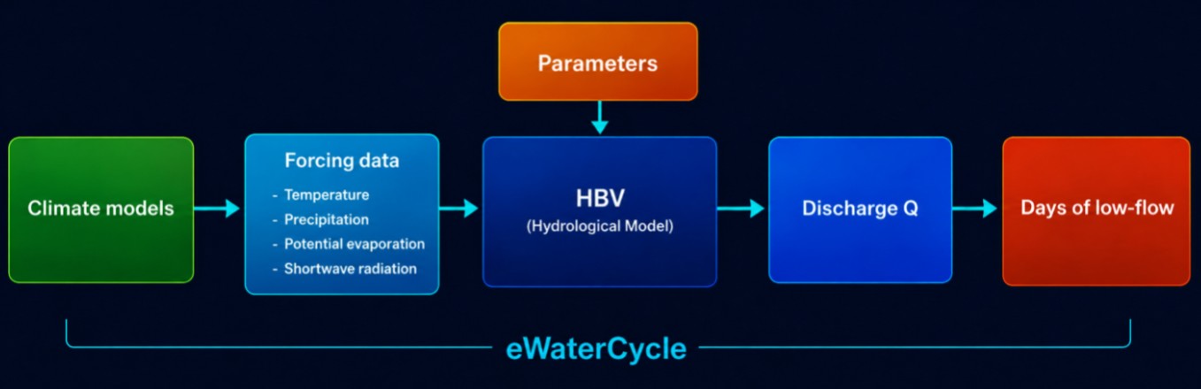
The hydrological analysis is carried out using the eWaterCycle platform. eWaterCycle is a hydrological modelling platform allowing users to run hydrological models, such as HBV, in a standardised and reproducible manner using Jupyter notebooks (eWaterCycle, n.d.). This makes it easy to switch between, to calibrate and to use various models. The platform simplifies accessing large databases such as ERA5 and CMIP6 which will be used for this research.
The HBV model is used to model discharge data in the LAR. It is chosen for the model to take ERA5 climate data and calibration parameters as input variables. The model is calibrated for the period 1999-2019 using observed discharge data at Fort McMurray, provided by the government of Canada. A random sampler approach is used in generating various parameter sets, where model performance is evaluated using the logarithmic Nash-Sutcliffe Efficiency (LNSE) to find the optimal parameter set. After calibration and validation, the model will be forced with CMIP6 forcings, containing simulated future climate data, alongside optimal parameters to model future discharge under various climate scenarios. See Figure 1 for a visualisation of how the model works using eWaterCycle. The output of this model is used to analyse the frequency of future critical low flow conditions with the aim of answering the research question.
1.5 Reading Guide#
In Chapter 2, a literature study will be conducted examining the region and identifying challenges that may arise for computational hydrology. This is followed by the determination of a critical discharge for navigation. In Chapter 3, the start and end period of the open water season will be determined. In Chapter 4, the model will be selected and justified, followed by calibration and validation justification and evaluation. In Chapter 5, climate scenarios are given and the model performance is evaluated under CMIP6 forcing inputs. The model will be used to model discharge in the future under climate scenarios in the results section in Chapter 6. This is followed by a discussion in Chapter 7 and a conclusion in Chapter 8.